Sacramento River At Red Bluff Diversion Dam
Back to River Summary
| Stage Color Key |
| 252.5 ft - Near Flood |
255.5 ft - Minor Flood |
257.6 ft - Moderate Flood |
261.6 ft - Major Flood |
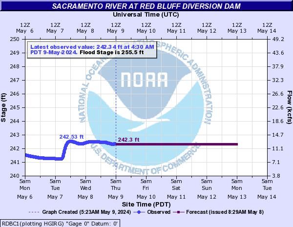
Latest Observation:
Friday April 19th, 2024 03:30 PM PDT
River Status:
Normal
| |
Height |
Flow |
| Currently |
242.08 ft |
11.4 kcfs |
| Record |
260 ft |
N/A |
| Forecast |
| |
Date (PDT) |
Stage (ft) |
Flow (kcfs) |
|
|
Friday 04/19/2024 05:00 PM |
242.00 |
11.00 |
|
|
Friday 04/19/2024 06:00 PM |
242.00 |
11.00 |
|
|
Friday 04/19/2024 07:00 PM |
242.00 |
11.00 |
|
|
Friday 04/19/2024 08:00 PM |
242.00 |
11.00 |
|
|
Friday 04/19/2024 09:00 PM |
242.00 |
11.00 |
|
|
Friday 04/19/2024 10:00 PM |
242.00 |
11.00 |
|
|
Friday 04/19/2024 11:00 PM |
242.00 |
11.00 |
| Observation |
| |
Date (PDT) |
Stage (ft) |
Flow (kcfs) |
|
|
Friday 04/19/2024 03:30 PM |
242.08 |
11.40 |
|
|
Friday 04/19/2024 03:15 PM |
242.08 |
11.40 |
|
|
Friday 04/19/2024 03:00 PM |
242.08 |
11.40 |
|
|
Friday 04/19/2024 02:45 PM |
242.08 |
11.40 |
|
|
Friday 04/19/2024 02:30 PM |
242.08 |
11.40 |
|
|
Friday 04/19/2024 02:15 PM |
242.08 |
11.40 |
|
|
Friday 04/19/2024 02:00 PM |
242.08 |
11.40 |
|
|
Friday 04/19/2024 01:45 PM |
242.08 |
11.40 |
|
|
Friday 04/19/2024 01:30 PM |
242.08 |
11.40 |
|
|
Friday 04/19/2024 01:15 PM |
242.08 |
11.40 |
|
|
Friday 04/19/2024 01:00 PM |
242.08 |
11.40 |
|
|
Friday 04/19/2024 12:45 PM |
242.08 |
11.40 |
|
|
Friday 04/19/2024 12:30 PM |
242.08 |
11.40 |
|
|
Friday 04/19/2024 12:15 PM |
242.08 |
11.40 |
|
|
Friday 04/19/2024 12:00 PM |
242.08 |
11.40 |
|
|
Friday 04/19/2024 11:45 AM |
242.08 |
11.40 |
|
|
Friday 04/19/2024 11:30 AM |
242.08 |
11.40 |
|
|
Friday 04/19/2024 11:15 AM |
242.08 |
11.40 |
|
|
Friday 04/19/2024 11:00 AM |
242.08 |
11.40 |
|
|
Friday 04/19/2024 10:45 AM |
242.09 |
11.40 |
Data Courtesy of the Advanced Hydrologic Prediction Service
Script Courtesy of Dennis at East Masonville Weather

 Air Quality


")


