Current Mesoscale Discussions
Updated:  Sat Apr 27 11:30:03 UTC 2024

Valid MD Image
MD Legend Image Mesoscale Discussion # 537
MD0537 Thumbnail Image Mesoscale Discussion #0537
Issued: 27/1029 UTC
Until: 27/1200 UTC
Concerning: SEVERE POTENTIAL...WATCH LIKELY

  All times are UTC

Notice:  The responsibility for Heavy Rain Mesoscale Discussions has been transferred to the Weather Prediction Center (WPC) on April 9, 2013. Click here for the Service Change Notice. Archived Convective Products
To view convective products for a previous day, type in the date you wish to retrieve (e.g. 20040529 for May 29, 2004). Data available since January 1, 2004.


 RSS Feed - SPC Mesoscale Discussions
 Storm Prediction Center
  • SPC MD 537

    Sat, 27 Apr 2024 10:31:03 +0000 UTC

    MD 0537 CONCERNING SEVERE POTENTIAL...WATCH LIKELY FOR PARTS OF NORTHWEST TX INTO WESTERN OK
    MD 0537 Image

    
    Mesoscale Discussion 0537
    NWS Storm Prediction Center Norman OK
    0529 AM CDT Sat Apr 27 2024
    
    Areas affected...Parts of northwest TX into western OK
    
    Concerning...Severe potential...Watch likely 
    
    Valid 271029Z - 271200Z
    
    Probability of Watch Issuance...80 percent
    
    SUMMARY...Severe storm development is possible toward sunrise. Large
    hail will be possible initially, but the tornado threat will
    increase through the morning. Watch issuance is likely prior to 7 AM
    CDT.
    
    DISCUSSION...Rich low-level moisture is streaming into parts of the
    TX South Plains and northwest TX this morning, in response to a
    strong southerly low-level jet noted on regional VWPs. Meanwhile, a
    strong mid/upper-level shortwave trough and attendant
    mid/upper-level jet are approaching the southern Rockies. A cirrus
    plume now moving over far west TX may be indicative of increasing
    ascent in advance of the shortwave. As this ascent begins to impinge
    on returning moisture across northwest TX, thunderstorm development
    is expected near or just before sunrise, with increasing storm
    coverage expected with time into parts of western OK. 
    
    Initial storm development will likely be somewhat elevated, but
    MUCAPE of greater than 2000 J/kg and strong effective shear will
    support supercell potential with an initial threat of large hail
    (potentially in the 1.5 - 2 inch diameter range). As storms spread
    into western OK, a transition to surface-based convection will be
    possible later this morning, as MLCINH quickly erodes with even
    modest diurnal heating. A transition to one or more clusters is
    possible as storm coverage increases with time this morning, but
    increasingly favorable low-level moisture and wind profiles will
    support embedded supercells with an increasing tornado threat. Watch
    issuance is likely prior to 7 AM CDT.
    
    ..Dean/Thompson.. 04/27/2024
    
    ...Please see www.spc.noaa.gov for graphic product...
    
    ATTN...WFO...OUN...LUB...AMA...
    
    LAT...LON   34029986 33970016 33960083 34230093 35110009 36019945
                36869914 36939846 36549794 36019782 35349799 34419848
                34029986 
    
    
    Read more

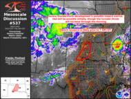
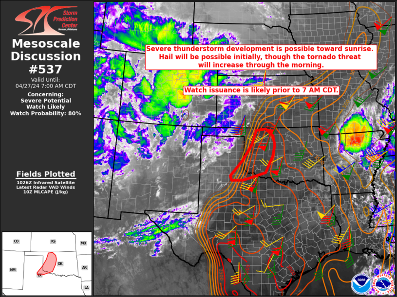
   NWS Current Mesoscale Discussions
powered by Cumulus v1.9.3 (1059)
Ambient Weather VWS v14.00
Weather-Display (10.37S-(b58))
Virtual VP software
Top Website Map Copyright © 2007 - 2024 Foresthillweather.com Never base important decisions on this or any weather information obtained from the Internet