
- Home
- Forecast
- Radar
- Maps
- WX-Data
- WX-Misc.
- Astronomy
- Fire
- About
- Links
 Air Quality
Space WX Alerts:
( Latest Alert ) - Issue Time: 2024 Apr 26 2300 UTC
39.8°F
Calm
Updated:
4/27/24 4:17am


")

| Advisories / Alerts |
| Severe Wx Summary! | ||||||||
 |
||||||||
|
||||||||
|
||||||||
 |
||||||||
| Sat, Apr 27, 2024 - 4:11am | ||||||||
|
|
|
|
|
|
Info Links


Yellowstone National Park Volcano

Volcanic Descriptions
- Volcano Alert Levels Description
- Aviation Color Codes Description
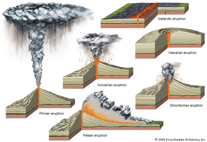
- Volcanic Eruption: Major Types
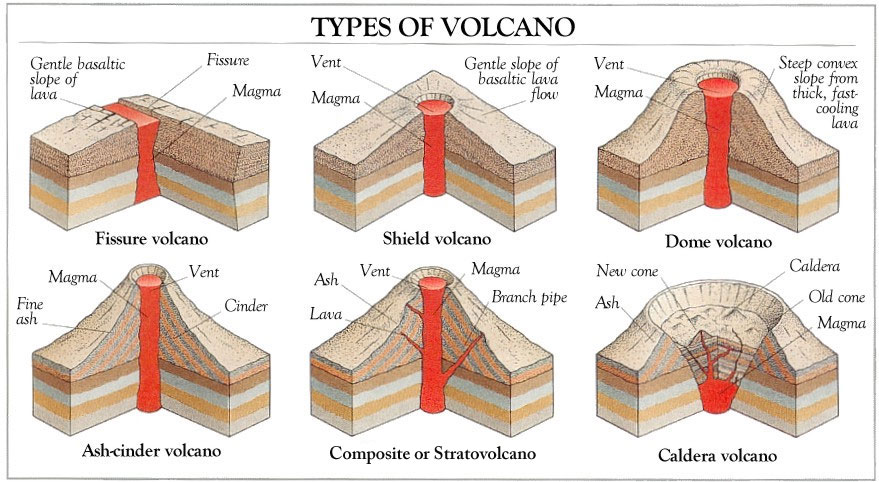
- Types of Volcanoes
| YELLOWSTONE VOLCANO (VNUM #325010) 44°25'48" N 110°40'12" W, Summit Elevation 9203 ft (2805 m) Current Volcano Alert Level: all NORMAL Current Aviation Color Code: all GREEN |
| YVO Yellowstone GREEN/NORMAL - YVO Monthly Update: background seismicity and deformation |
| Apr 1, 2024 18:16 - Recent Work and NewsThere were no major eruptions of Steamboat Geyser during the month of March, although minor eruptions have been ongoing since the middle of the month, suggesting that a major eruption could occur within the next few days to weeks. The geyser has erupted once so far in 2024 (on February 26). SeismicityDuring March 2024, the University of Utah Seismograph Stations, responsible for the operation and analysis of the Yellowstone Seismic Network, located 96 earthquakes in the Yellowstone National Park region. The largest event of the month was a minor ... [ More ] |
| (click to enlarge) |

")

New Mammoth Hot Springs ") |
Mammoth Hot Springs Terrace ; "Old Mammoth Hot Springs (click to enlarge)") |
Mount Washburn ") |
Information courtesy of ...
U.S. Geological Survey, Yellowstone National Park,
and University of Utah
U.S. Geological Survey, Yellowstone National Park,
and University of Utah
- USGS Cascades Volcano Observatory
- Cascade Range Current Update
- USGS Alert-Notification System for Volcanic Activity
- Volcano Observatories: Alaska
- Volcano Observatories: Cascades
- Volcano Observatories: Hawaii
- Volcano Observatories: Long Valley
- Volcano Observatories: Mariana Islands
- Volcano Observatories: Yellowstone


powered by Cumulus v1.9.3 (1059)
Ambient Weather VWS v14.00 Weather-Display (10.37S-(b58))
Virtual VP software Top Website Map Copyright © 2007 - 2024 Foresthillweather.com Never base important decisions on this or any weather information obtained from the Internet
Ambient Weather VWS v14.00 Weather-Display (10.37S-(b58))
Virtual VP software Top Website Map Copyright © 2007 - 2024 Foresthillweather.com Never base important decisions on this or any weather information obtained from the Internet