
- Home
- Forecast
- Radar
- Maps
- WX-Data
- WX-Misc.
- Astronomy
- Fire
- About
- Links
 Air Quality


")

| Advisories / Alerts |
| Severe Wx Summary! | ||||||||
 |
||||||||
|
||||||||
|
||||||||
 |
||||||||
| Sat, Apr 27, 2024 - 12:51am | ||||||||
|
|
|
|
|
|
Info Links


Volcanic Descriptions
- Volcano Alert Levels Description
- Aviation Color Codes Description
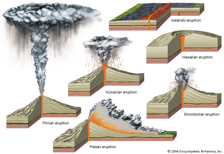
- Volcanic Eruption: Major Types
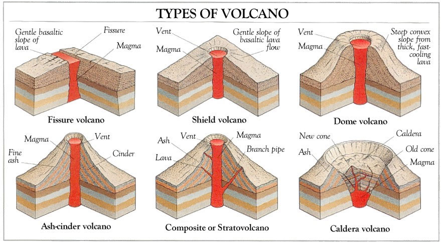
- Types of Volcanoes
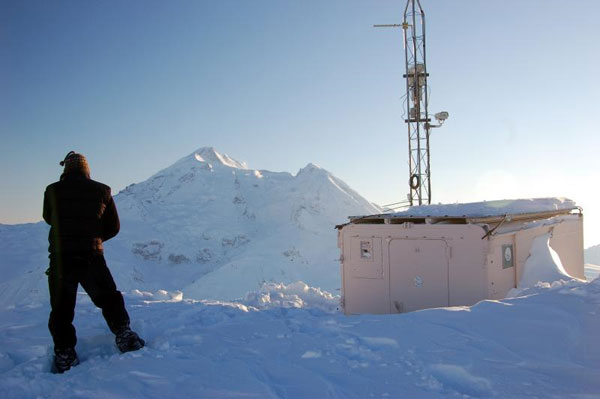
Mt. Redoubt Volcano Statistics
|
Mt.Redoubt Volcano Location")
|
Description
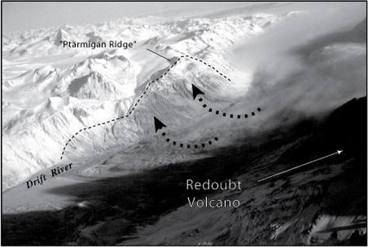
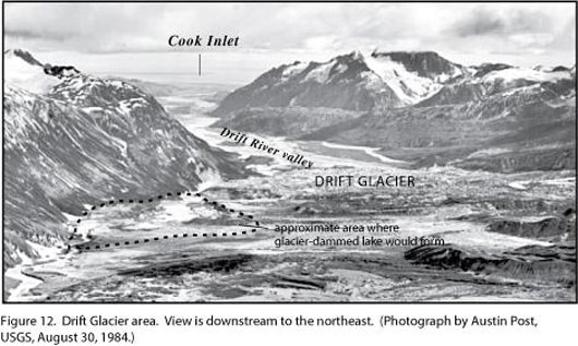
From Miller et al (1998): "Redoubt Volcano is a steep-sided cone about 10 km in diameter at its base and with a volume of 30-35 cubic kilometers. The volcano is composed of intercalated pyroclastic deposits and lava flows and rests on Mesozoic granitic rocks of the Alaska-Aleutian Range batholith (Till and others, 1993; 1994). It has been moderately dissected by the action of numerous alpine glaciers. A 1.8-km-wide, ice-filled summit crater is breached on the north side by a northward-flowing glacier, informally known as the Drift Glacier, which spreads into a piedmont lobe in the upper Drift River Valley. The most recently active vent is located on the north side of the crater at the head of the Drift glacier. Holocene lahar deposits in the Crescent River and Drift River valleys extend downstream as far as Cook Inlet."
ALASKA VOLCANO OBSERVATORY WEEKLY UPDATE
U.S. Geological Survey
Friday, April 26, 2024, 11:47 AM AKDT (Friday, April 26, 2024, 19:47 UTC)
GREAT SITKIN (VNUM #311120)
52°4'35" N 176°6'39" W, Summit Elevation 5709 ft (1740 m)
Current Volcano Alert Level: WATCH
Current Aviation Color code: ORANGE
The eruption of lava within the summit crater of Great Sitkin Volcano continues. Satellite radar data through April 21, 2024, showed continued advance of lava flow lobes to the northwest and continued uplift of the lava flow surface above the vent. Cloudy conditions obscured satellite and web camera views of the summit over the past week. Seismic activity was low, with occasional small volcanic earthquakes.
The current prolonged period of lava eruption at Great Sitkin Volcano began in July 2021. No explosive events have occurred since a single event in May 2021.
The volcano is monitored by local seismic, geodetic, and infrasound sensors and web cameras, as well as regional infrasound and lightning networks and satellite data.
Great Sitkin Volcano is a basaltic andesite volcano that occupies most of the northern half of Great Sitkin Island, a member of the Andreanof Islands group in the central Aleutian Islands. It is located 26 miles (43 km) east of the community of Adak. The volcano is a composite structure consisting of an older dissected volcano and a younger parasitic cone with a ~1 mile (1.5 km)-diameter summit crater. A steep-sided lava dome, emplaced during the 1974 eruption, occupies the center of the crater. That eruption produced at least one ash cloud that likely exceeded an altitude of 25,000 ft (7.6 km) above sea level. A poorly documented eruption occurred in 1945, also producing a lava dome that was partially destroyed in the 1974 eruption. Within the past 280 years a large explosive eruption produced pyroclastic flows that partially filled the Glacier Creek valley on the southwest flank.
SHISHALDIN (VNUM #311360)
54°45'19" N 163°58'16" W, Summit Elevation 9373 ft (2857 m)
Current Volcano Alert Level: ADVISORY
Current Aviation Color code: YELLOW
Low-level unrest continues at Shishaldin Volcano, with occasional small volcanic earthquakes and weak seismic tremor being observed throughout the week. Sulfur dioxide emissions were detected on April 19 and 20 with satellite-based sensors, but no ash emissions or new deposits were observed in satellite data. Weak steam emissions were occasionally seen in webcam views when the summit was clear. No changes at Shishaldin's summit were observed in satellite radar data, but minor rock falls associated with collapse events from the unstable ground in and near the summit crater are possible. These events may generate very small clouds of fine-grained ash that dissipate quickly in the immediate vicinity of the summit.
No significant eruptive activity has occurred since November 2023.
Local seismic and infrasound sensors, web cameras, and a geodetic network are used to monitor Shishaldin Volcano. In addition to the local monitoring network, AVO uses nearby geophysical networks, regional infrasound and lighting data, and satellite images to monitor the volcano.
Shishaldin Volcano, located near the center of Unimak Island in the eastern Aleutian Islands, is a spectacular symmetric cone with a base diameter of approximately 10 miles (16 km). It is one of the most active volcanoes in the Aleutian volcanic arc, with at least 54 episodes of unrest including over 28 confirmed eruptions since 1824. Most eruptions are relatively small, although activity during July – November, 2023 generated ash columns that reached between 30,000 ft (9 km) and 42,000 ft (13 km) above sea level.
Source: Alaska Volcano Observatory


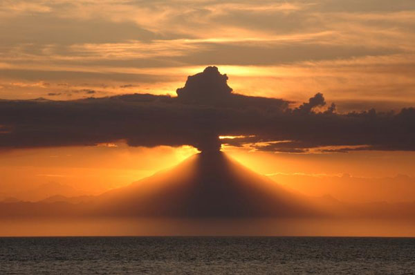
This is a static image of Mount Redoubt,
The VolcanoCam image automatically updates approximately every two hours.
Volcano image courtesy of ...
Live webcam images of various Alaskan volcanoes
Alaska Volcano Observatory Webcam - Redoubt - DFR


| Augustine volcano (VNUM #313010) 59.3626° N 153.435° W, Summit Elevation 4134 ft (1260 m) Current Volcano Alert Level: 33 Current Aviation Color Code: |

U.S. Geological Survey, the University of Alaska Fairbanks Geophysical Institute, and the Alaska Division of Geological and Geophysical Surveys.
- USGS Cascades Volcano Observatory
- Cascade Range Current Update
- USGS Alert-Notification System for Volcanic Activity
- Volcano Observatories: Alaska
- Volcano Observatories: Cascades
- Volcano Observatories: Hawaii
- Volcano Observatories: Long Valley
- Volcano Observatories: Mariana Islands
- Volcano Observatories: Yellowstone


)
)
Ambient Weather VWS v14.00 Weather-Display (10.37S-(b58))
Virtual VP software Top Website Map Copyright © 2007 - 2024 Foresthillweather.com Never base important decisions on this or any weather information obtained from the Internet