
- Home
- Forecast
- Radar
- Maps
- WX-Data
- WX-Misc.
- Astronomy
- Fire
- About
- Links
 Air Quality


")

| Advisories / Alerts |
| Severe Wx Summary! | ||||||||||||
 |
||||||||||||
|
||||||||||||
|
||||||||||||
 |
||||||||||||
| Mon, Apr 29, 2024 - 4:51am | ||||||||||||
|
|
|
|
|
|
Info Links


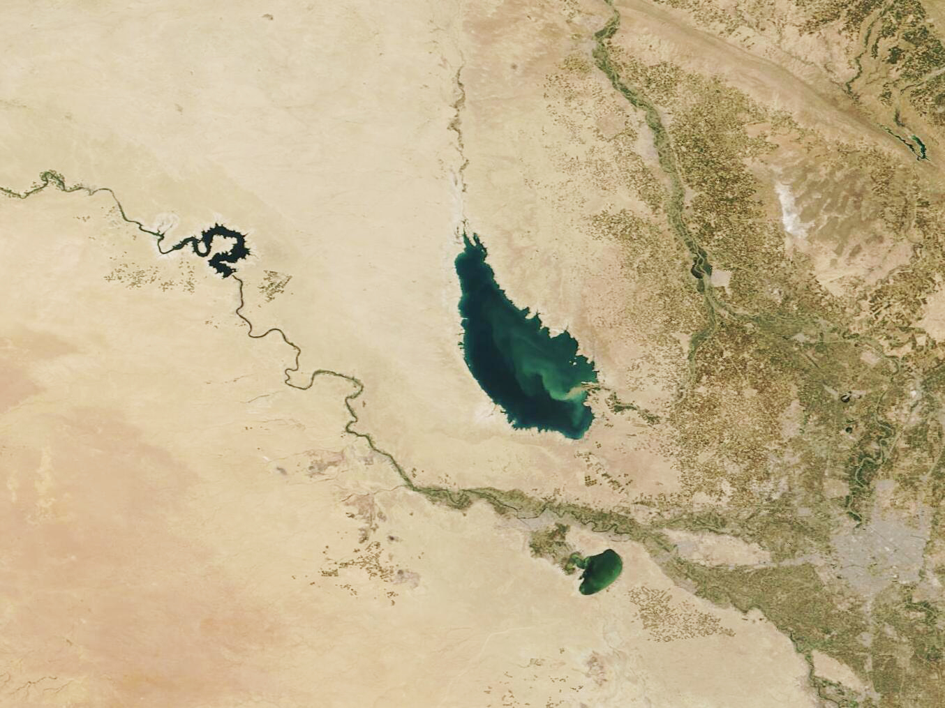
| Shrinking Lake Tharthar | |||
|
|||
April 29, 2024 |
|||
|
April 17, 2024 April 11, 2004 Tweet Share
Sitting in the Middle East between Iran and Kuwait, Iraq is dominated by dry desert landscape as well as traversed by two ancient rivers: the Tigris and the Euphrates. These rivers flow southeastward from the northern highlands across Iraq’s alluvial plains until they reach the Persian Gulf. Many lakes, both man-made and natural, dot the plains between the two major rivers, including Lake Tharthar, which was created in 1956 primarily for water storage and to hold floodwater from the Tigris River. The many lakes, as well as the rivers, provide livelihoods as well as water for drinking, agriculture, and other uses for most of Iraq’s population. Over several decades, the country has experienced significant changes to the climate, including a significant reduction in rainfall and increasing evaporation rates, spurred by rising temperatures. According to ReliefWeb, Iraq is one of the five most vulnerable countries in the world to climate change. The article, which was published in November 2022, explains that desertification affects 39 percent of Iraq’s territory, with very high temperatures more common, drought more frequent, and dust storms becoming more intense. These The environmental stresses and increasing demands for water for agricultural and other uses has profoundly affected water levels in many lakes, including Lake Tharthar. A pair of true-color images acquired by the Moderate Resolution Imaging Spectroradiometer (MODIS) on NASA’s Terra satellite acquired twenty years apart shows the changes in water levels in the lakes and rivers north of Baghdad over time. The first image, acquired on April 17, 2024, centers on Lake Tharthar. The Euphrates river and Haditha Dam Lake can be seen running across the image south of Lake Tharthar. Both are surrounded by desert. The Tigris River is northeast of the lake, with little water visible within the banks, a green flood plain, and what appears to be agricultural fields surrounding it. In the southeast corner, gray pixels mark the city of Baghdad, the capital of Iraq which sits on the Tigris River. Lake Habbaniyah sits south of Lake Tharthar and west of Baghdad. Clicking on the date under the image reveals a second true-color Terra MODIS image acquired on April 11, 2024. All three lakes are much larger and the Tigris River appears to also be wider and more visible, including the region flowing through Baghdad. The agricultural regions near the Tigris are also notably smaller.
|
|||
| Image Facts Satellite: Terra Date Acquired: 4/17/2024 Resolutions: 1km (103.5 KB), 500m (295.9 KB), 250m (649.8 KB) Bands Used: 1,4,3 Image Credit: MODIS Land Rapid Response Team, NASA GSFC |
|||
| Courtesy of NASA MODIS Website | |||


Ambient Weather VWS v14.00 Weather-Display (10.37S-(b58))
Virtual VP software Top Website Map Copyright © 2007 - 2024 Foresthillweather.com Never base important decisions on this or any weather information obtained from the Internet